Heavy rainfall sparks evacuations
Written by admin on June 8, 2024
Residents of Sydney’s outskirts are under evacuation orders as flood waters continue to rise due to days of heavy rainfall.
Emergency warnings were issued overnight, with evacuations ordered for several places along the Hawkesbury River.
These places include parts of Agnes Banks, Cornwallis, eastern part of Richmond Lowlands, Pitt Town Bottoms, northern part of Pitt Town (around Percy’s Place Caravan Park), parts of Cattai, Sackville, Cumberland Reach and all the way to Lower Portland.
NSW State Emergency Service (SES) has reported 44 warnings are currently in place, performing 13 flood rescues so far as 297 incidents were occurred overnight to Saturday morning.
Prior to the rainfall, the Bureau of Meterology (BOM) had issued flood warnings for both the Nepean and Hawkesbury rivers.
Other areas with flood warnings include the Cooks River, Georges and Woronora Rivers, Shoalhaven River and St Georges Basin.
“Major flooding is possible along the Hawkesbury River at North Richmond and moderate flooding is occurring at Windsor. Minor flooding is peaking along the Nepean River at Penrith and possible along the Hawkesbury River at Sackville,” the BOM states.
However, the BOM has forecasted “no further significant rainfall” over the next couple of days.
While river levels are falling in some areas, places such as the Nepean River at Yarramundi, Grose River at Burralow and the Hawkesbury River at Windsor are still rising.
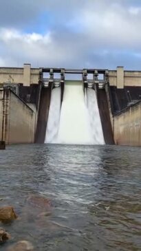
This follows as water from the Warragamba Dam spilt over into the Hawkesbury and Nepean Rivers.
Newswire has reached out to SES for comment.
New South Wales/Australian Capital Territory
Along with multiple minor and moderate flood warnings in places across the Hawkesbury and Nepean Rivers, BOM has issued a gale warning for Batemans Coast.
There’s also strong wind warnings for the Hunter Coast, Sydney Coast, Illawarra Coast and Eden Coast.
In Sydney, it’s expected to be partly cloudy with a slight chance of more showers and a maximum temperature of 21 on Saturday.
It’s expected to be partly cloudy in Canberra with a slight chance for showers and a maximum temperature of 17.
South Australia
Frost warnings have been issued for the Mid North and Riverland districts, with frost temperatures reaching minus one degrees.
It’s forecasted to be slightly cloudy in the Adelaide area, with slight chances of a drizzle and a maximum temperature of 16.
Victoria
Strong wind warnings have been issued along the East Gippsland Coast and are expected to continue into Sunday.
In Melbourne, it’s expected to be a cloudy day, with chances of a morning fog rolling in and showers in the evening, maximum temperature of 15.
Tasmania/Northern Territory/Queensland
No weather warnings have been issued for these states.
Mostly sunny in the Hobart area, with chances of cloudy weather later in the day. Patchy morning fog has been forecasted with a slight chance of a shower later in the evening, maximum temperature of 13.
A sunny day for the Sunshine State’s capital, with some light winds and a maximum temperature of 22.
Areas of smoke haze have been forecasted for Darwin City and the Outer Darwin area, with a sunny day expected and maximum temperature of 29.
More Coverage
Western Australia
Strong wind warnings have been issued for the Gascoyne Coast, Geraldton Coast, Bunbury Geographe Coast and Leeuwin Coast.
In Perth, it’s forecasted to be partly cloudy with a high chance of showers and a maximum temperature of 21.
Read related topics:Sydney